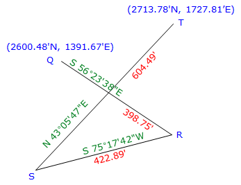
b. Link Traverse
 |
|
Figure I-6 |
Previously computed unadjusted latitudes and departures are:
|
Line |
Direction |
Length |
Lat |
Dep |
|
QR |
S 56°23'38"E |
398.75' |
-220.700' |
+332.104' |
|
RS |
S 75°17'42"W |
422.89' |
-107.347' |
-409.038 |
|
ST |
N 43°05'47"E |
604.49' |
+441.402' |
+413.004' |
|
|
sums: |
1426.13' |
+113.355' |
+336.070 |
(1) Compute preliminary coordinates:
|
Point |
North (ft) |
East (ft) |
|
|
Q |
2600.480 |
1391.670 |
|
|
LatQR |
-220.700 |
DepQR |
+332.104 |
|
R |
2379.780 |
|
1723.774 |
|
LatRS |
-107.347 |
DepRS |
-409.038 |
|
S |
2272.433 |
|
1314.736 |
|
LatST |
+441.402 |
DepST |
+413.004 |
|
T |
2713.835 |
|
1727.740 |
Lat err = 2713.835' - 2713.780' = +0.555'
Dep err = 1727.740'-1727.810' = -0.070'
(2) Compute and apply corrections to the coordinates using the Compass Rule, Equation I-3.
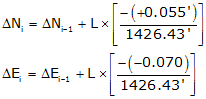
Computations for each line are not shown, but their results are tabulated below.
|
Point |
N' (ft) |
ΔN (ft) |
N (ft) |
E' (ft) |
ΔE (ft) |
E (ft) |
|
S |
2379.780 |
-0.015 |
2379.765 |
1723.774 |
+0.020 |
1723.794 |
|
T |
2272.433 |
-0.031 |
2272.402 |
1314.736 |
+0.041 |
1314.777 |
|
Q |
2713.835 |
-0.054 |
2713.781 |
1727.740 |
+0.071 |
1727.811 |
|
check |
check |