A. Definitions
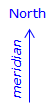
1. Meridian
A meridian is a north-south reference line. It is used as a basis for a direction, which describes a line’s orientation.
Common meridians include, but are not limited to, Figure A-1:
|
|
|
| Figure A-1 Meridians |
||
`
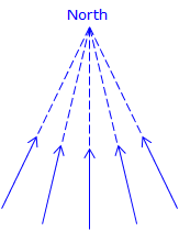
Depending on the system, meridians may converge or may stay parallel, Figure A-2.
|
|
|
| (a) Parallel | (b) Converging |
|
Figure A-2 |
|
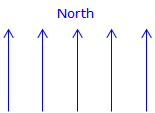
Plane Surveying: Parallel meridians are typical in Grid and Assumed systems. For small project areas such as a single lot survey, meridians can assumed to be parallel, regardless of system, without introducing significant error.
Geodetic Surveying: In a larger earth-based system meridians converge to a point (e.g., North Pole).
Most meridian systems (even Assumed) are constant over time. However, magnetic meridians change location and their change is not consistent. Magnetic meridians are important as the first instrument extensively used for property surveys was the compass. Although True directions were reported in the early Public Land Surveys, they were first measured by compass then converted using solar observation.
A surveyor will select an appropriate meridian for the project at hand and orient all survey lines to it. Sometimes directions based on one meridian must be converted to a different meridian in order to maintain consistency across surveys. We’ll look at that, along with magnetic direction conversions, in Meridian Conversions later.
We will use parallel meridians for the remainder of this discussion - convergency issues will be covered in a later Topic.