3. Adjacent Survey
Not all surveys are referenced to a formal meridian. Some surveyors assume the direction of one line which serves as the basis for the remaining lines. As long as the survey stands alone and otherwise meets it objectives (eg, parcel area, physical line locations, etc), an assumed direction is fine. However, if the survey will be integrated with others, they must all have the same direction reference.
This can happen when two adjoining parcels are surveyed by different surveyors at different times. Individually, the surveys may be high quality and meet the clients' needs. But they won't map together correctly if each used a different direction assumption - it will appear that the surveys are rotated with respect to each other..
For example:
Surveyor Jones is hired to survey Lot 3 in a subdivision. Because one line runs close to north-south, he assumed its direction as North and completed his survey, His final directions after traverse adjustment are shown in Figure C-18.
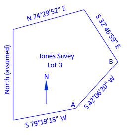 |
| Figure C-18 Jones Lot 3 Survey |
Surveyor Black surveyed Lot 2, on the southeast side of Lot 3. She started with an assumed direction of N 50°00'00" W on one line. Her final line directions are shown in Figure C-19.
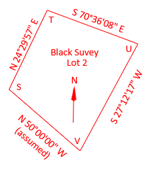 |
| Figure C-19 Lot 2 Survey |
The common line between Lots 3 and 2 is Jones' line AB and Black's line ST. Because the lines have different directions in each survey, there will be a problem plotting the surveys together on a single map. Whether points B and T coincide, Figure C-20, or points A and S coincide, Figure C-21, the common line will will be rotated between surveys.
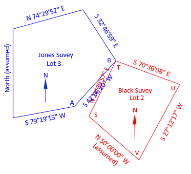 |
| Figure C-20 Common Points B and TM |
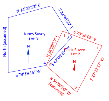 |
| Figure C-21 Common Points A and S |
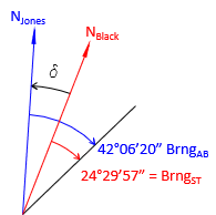
Assuming a direction, each surveyor fixed their respective north meridians. The angle between the common lines in Figures C-20 and C-21 is the angular difference between their north meridians.
Even though Figures C-20 and C-21 show two different lines, that is not the real situation. There is only one line but two different norths, Figure C-22
 |
| Figure C-22 Meridian Difference |
Using a single common line, we can reconstruct where the surveyors' assumed north meridians were:
- Jones' was 42°06'20" northwest of the common line
- Black's was 24°29'57" northwest of the common line.
The angle between their meridians, δ, is:
![]()
This angle is used to convert Black's directions to Jones' north meridian.
Stepping through the remaining three lines of Lot 2:
| Line TU | |
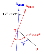 |
|
| BrngTU = S 52°59'45" E | |
| Line UV | |
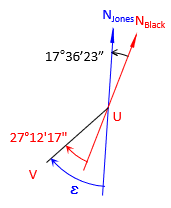 |
|
| BrngUV = S 44°48'40" W | |
| Line VS | |
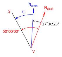 |
|
| BrngVS = N 32°23'37" W | |