A. Maps
1. Introduction
a. What is a map?
A map is a graphic representation of object sizes and locations. Because its coverage and detail are limited, a map is an abstraction of reality with some compromises made on how and what information is shown. A map is a graphic communication medium and should be self-explanatory.
A map is created with a particular emphasis or theme. Figure A-1 is a mid-18th century map of the Northwest Territory.
|
|
|
Figure A-1
Northwest Territory
|
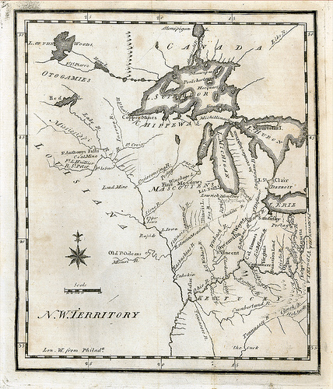
The most distinctive map features in Figure A-1 are major waterways. Because they were important transportation networks and highways of commerce, the map emphasized them in detail The overall visual geography of the territorial area is influenced by the waterway mapping.
b. Maps and Surveyors
Surveyors create maps as well as use them. This topic's scope is basic map composition. Understanding general map principles and characteristics help create more effective maps. Map making is a lot like writing: the more it's done, the better it becomes.
A map can be a traditional paper product or a digital model. The formats may differ but they share some common characteristics. Both:
- are a simplified representation of reality
- depend on data collection to provide sufficient accuracy, and
- require skill and knowledge to faithfully communicate spatial information.
These are important since surveyors generally create maps for other users. A map that can't be understood or doesn't meet a specified need is a waste of time and resources.
c. Disclaimer
This topic is not intended as a definitive map treatise; think of it more as a beginner's guide. Cartography and Geographic Information Sciences offer a wealth of information on map composition, aesthetics, etc, and are a mere internet search away.